
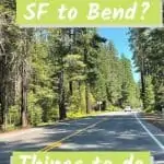
Driving From San Francisco To Bend, Oregon – Great Stops Along The Way
Last year we helped my sister-in-law move from Alaska to Oregon to be closer to her aging mom. So now we have the opportunity to explore all the sites while driving from San Francisco to Bend; Yay!
Anecdotally, we’ve heard rumors that “techies” have been moving from the SF Bay Area to Bend. Bend’s Mayor, Sally Russell, said, “The recent growth of telecommuting may play a role in people leaving major cities like Seattle and San Francisco for Central Oregon.” Surveys show that at least 20% of Bend’s workforce works remotely.

This sleepy little town in Eastern Oregon, with great outdoor activities from hiking and biking to tubing the river in summer and skiing in winter, has become quite the place to live or visit. All this makes driving from San Francisco to Bend more popular than ever.
This article may contain affiliate links. We may earn a commission if you use these links to buy products or services. Please see our disclosure policy for full details. Thanks.
How Long Does Driving From San Francisco To Bend Take?
The road trip from the Bay Area to Bend takes you up Interstate 5 (I5) to Weed, CA, connecting with US Highway 97 and heading straight to Bend. You can easily make this trip in one day. The drive is about 490 miles; if you average 50 miles per hour, it will take around 10 hours for the trip.
This allows for bio-breaks and one more extended gas and food break. If you split the drive into two or more days, there are some great places and sites to visit.
San Francisco to Bend, Oregon flights are available, and we’ve taken these on occasion. But then you miss out on the opportunity to see some beautiful country.
In my post on Seattle, I mention that the Cascade Mountain Range runs for over 700 miles from Lassen Peak in Northern California to the Fraser River in British Columbia. A good portion of this drive follows that range and its volcanoes.
Easy detours on the drive are Lassen Volcanic National Park, an active volcano that last erupted in 1915. Mt. Shasta, a stratovolcano that last erupted in 1786, and Crater Lake National Park is in the belly of a now dormant volcano. More about these sites later on in this post.
Good Places To Stop On The Drive North To Bend
As you head out of the Bay Area, you want to put some distance in to get away from traffic before stopping. But, you also probably had your morning coffee as you headed out and may need a bio-break. You are in luck; just before the turnoff to I-505 is the Vacaville Premium Outlets.
Now I’m really not that big a shopper, but if you read my other post on driving south to LA on the 101, you know I like to stop at the Outlets. Why? Simple, the Outlets provide clean bathrooms and easy access on and off the highway.
Also, at the outlet malls, you will find sit-down restaurants if you are hungry, drive-thru’s if you just need a pick-me-up, and of course, all the shopping you may want to do.

Interstate 505 (mentioned above) is the road that will connect you with Interstate 5 North without having to drive through Sacramento.
This is a bonus while driving from San Francisco to Bend, no traffic, just agriculture.
Suppose you didn’t stop at the Outlets but find yourself needing to stretch a bit or the kids need to run off some energy.
In that case, a quick stop at the Sacramento National Wildlife Refuge is a great choice.
Located just south of Willows on the East side of I-5, the Refuge is accessible, has a gift shop and clean restrooms. At the Visitor Center, take a few minutes to get oriented. Then head out on a Wetland Walk or drive through the Refuge following one of their unique Auto Tours. Deer, otters, and birds of many feathers live at the Refuge so have your camera ready.
The First Big Detour – Lassen Volcanic National Park
It’s been my goal since I can’t remember when to see Bumpass Hell. This part of the Park usually opens around the middle of July due to snow.
However, California is headed into a big drought season, and there hasn’t been much snow this year. Lassen was able to open in late June fully. So when we hit Red Bluff, we make our first detour and head east about 50 miles to Lassen Volcanic National Park.

Going to Lassen is a significant detour when you are driving from San Francisco to Bend. My desire to see Bumpass Hell makes the two-plus-hour detour worth it.
This is a mini-vacation for us, so we decide to go slow and see the sites. Only going to one location in Lassen means we can do this in an afternoon.
If you want to drive the whole Park (fun and beautiful), plan for this to be a day trip.
Bumpass Hell is Lassen Volcanic National Park’s largest hydrothermal area. It’s located a short 6-mile drive from the South Entrance to the Park and the Kohm Yah-mah-nee Visitor Center.
However, getting from the trailhead on the main road down to this geothermal area requires a 3-mile round-trip hike.
Down is a weird modifier for this hike, as much of it on the way to Bumpass Hell feels like you are headed uphill.
The down part comes at the very end when you hike down around 300 feet to the crazy 16-acre basin of boiling mud pots, bubbling pools, and roaring steam vents.

Remember, whenever you go down, you have to come back up…
Is the hike worth it? Yes, you don’t see these types of geological features in very many places.
The hike is rated easy on All Trails. But don’t be fooled into thinking this is a walk in the park. The trail is narrow rocky and crowded. A lot of people want to see Bumpass Hell.
Tips For Hiking To Bumpass Hell
Get to the trail as early as you can. This may be the most popular site in the Park, and the parking area will fill up by mid-morning.
Wear proper hiking shoes, sunscreen, and a hat. Take water with you and a good walking stick for extra stability. I picked up these collapsible walking sticks recently, and I enjoy hiking with them.

Take your time on the hike, enjoy nature, and be careful. On the day we were there, someone ahead of us sprained their ankle severely and could not hike out. The Park Ranger’s Rescue Crew had to hike to the bottom, put the injured person on a liter, and carry them out.
America the Beautiful Pass – National Park Passes

The entrance fee for Lassen is $30.00 per car. However, you may be visiting more than one park this year. In that case, I highly recommend getting an America the Beautiful Pass from the National Parks Service. You can purchase your annual pass when you arrive at most National Parks, so we buy our Annual Pass here at Lassen.
This annual pass is available to the general public. You get access to all National Parks and recreation sites that charge an entrance or standard amenity fee for one year, beginning from the month of purchase.
(Note: The pass does not cover overnight camping in the parks. These are separate use charges, but your pass may provide a discount on these services.)
There are several types of Park passes, and the cost for each varies depending on your qualifications. Once you are 62 and older, you can get a lifetime pass for just $80.00! Sometimes age has benefits!
See The Trains in Dunsmuir
After your detour, head back to I-5 and continue the drive north. About an hour north of Redding is Dunsmuir, CA, which sits right next to the Highway. What is unique about Dunsmuir? Trains.
If you, your kids, or your significant other like trains, there are some beauties here for you to have a quick look at.
There is a railroad museum, but it’s only open one day a month. There is a caboose to climb on and a locomotive to take a look at.
Want to see even more trains? Check out the Rail Road Park Resort, where you can eat on a train or sleep in a Caboose. They even have an RV Park and Campground.

We quickly stopped in Dunsmuir to gas up and look at an old steam engine. My father-in-law is a train buff and artist. He spent some time drawing this locomotive many years ago. You can see this engine and other works on his Facebook page https://www.facebook.com/SteamTrainArtwork/.

It’s been a long day so far, and as we leave Dunsmuir, we are happy to be headed to our hotel in Mt. Shasta. But you may have time for one more stop.
Lake Shasta Caverns National Natural Landmark
Do you like spelunking? Assuming you don’t encounter fires and still have time and energy left in your day, a stop at Lake Shasta Caverns can be a fun way to wrap up your day. Exit I-5 at Shasta Caverns Road, about 18 miles north of Redding. Follow Shasta Caverns Road east for about 7 miles, and you will find the Caverns.
Tours of the caverns last about two hours and take you on a boat ride on Shasta Lake and a guided tour through the underground cave.
When driving from San Francisco to Bend in the summer, you look for places to cool off. Summer in this area can be in the high 90s to low 100s. Spending a bit of time on the lake and underground in the coolness of the caves is a fantastic way to stretch your legs and see a unique site.
Mt. Shasta The Midway Point On The Drive To Bend
We are often asked where to stay between Bend and San Francisco. Mt. Shasta (the town) / Weed (also a town) represents the midway point of driving from San Francisco to Bend, and we stay the night in Mt. Shasta at the Best Western Tree House.
Typically, you get to Weed on I-5 and then transition to US Highway 97, which is the straight shot up to Bend. But California in a drought is never typical. We have been watching the reports from Cal-Fire, following the active fires in the area.
We learn that the Lava Fire burning in the foothills leading up to Mt. Shasta (the mountain/volcano) covers about 20,000 acres, has jumped Highway 97, and is only 19% contained. Highway 97 from Weed pretty much to the Oregon border is closed.

There was far too much smoke in the air to see Mt. Shasta as we drove from San Francisco to Bend. But the photo above is what you could see on a clear day.
We also encounter the Salt Fire burning close to I-5, which slows us down considerably. Cal-Fire has closed all but one lane of I-5. The drive from Dunsmuir to Mt. Shasta, which should only take 30 minutes or less, turns into an hour and a half with lots of smoke and fire-fighting excitement.
Helicopters and planes fly back and forth, from Lake Shasta, where they pick up water, to the fire to dump the water. At one point, we see that the fire has been right down to the roadway, and fire retardant is everywhere.
Thinking ahead, I have already mapped out our alternate route to Crater Lake using I-5 N to Oregon and then cutting over on Highway 62 outside of Medford. I like to use AAA’s TripTik for mapping, so we have printed maps to bring along.
Pro Tip: Don’t count on cell service for mapping when taking long road trips. You may not have service in rural areas and the mountains. For much of this trip, there was no service. It’s good to have a hard copy of a map laminated if you need it.
Day Two: Driving From San Francisco To Bend – Crater Lake National Park
Because of the Lava Fire by Mt. Shasta, we have to make a detour. Instead of driving up US Highway 97, which is closed, we head up I-5. This doesn’t really change our overall plans. We intend to make a stop at Crater Lake National Park on our drive to Bend. But It does add about 30 miles and 30 minutes to our drive.
Right across the Oregon border from California, about 60 miles from Mt. Shasta, is a relatively new and expansive rest stop on the East side of I-5. The ease of access makes this a good place for a bio-break. It’s easier than trying to find a stop in Ashland or Medford.

When you reach Medford, right around the local airport, you connect to Oregon Highway 62 East. You do have to go through town a bit to get to 62, so watch the way signs, especially around the airport.
But if you are looking for coffee, you will also find a slew of drive-thru coffee houses to take your pick of.
Once on 62 outside of Medford, the drive will take about 1 ½ hours (65 miles) to get to Crater Lake.
The highway (62 East) is pretty empty, so we really enjoy the ride through the mountains and forest. When we get to the Park, 62 forms a “T” intersection with the park entrance. Here there is a traffic jam.
Crater Lake is very popular, and the traffic coming from US 97 to the East is backed up quite a ways. The road into the park is one long line of cars.
We patiently wait our turn and find another bonus to having an annual pass. On the road leading to the park entrance, a Ranger is speaking with the occupants of all the cars. When she reaches us, she asks if we have an Annual Pass. Of course, we say yes.
We are then directed to the “express lane” that allows us to pass by about 25 cars and into the Park. If it takes just two minutes per car in the regular lane, we figure this saves us about 45 minutes of sitting in our car. Yay!
Crater Lake National Park – A Now Dormant Volcano
Established in 1902, Crater Lake lies in the belly of a dormant volcano and is the fifth-oldest national park in the United States. This volcano once stood 12,000 feet tall, but the volcano collapsed after a major eruption 7,700 years ago. What was left is now Crater Lake National Park, the deepest lake in the United States, at a depth of 1,943 feet.

Scientists consider Crater Lake to be one of the cleanest and clearest bodies of water in the world. The intense blue color is an indication of its great depth and purity. Entirely surrounded by cliffs, the lake is fed solely by rain and snow.
We start our visit at Rim Village and the Sinnot Memorial Overlook. I recommend this as your starting point, even if you plan to drive all around the lake. Here there are restrooms, Park Rangers, information booths, and a fantastic viewing platform. The enclosed viewing platform allows a full 360 view of the lake.
We only drive a small portion of the Rim Drive. Remember, we are driving from San Francisco to Bend, and Crater Lake is just a short diversion. But with the Rim Drive being open, we can exit the park at the North Junction (on the West Side of the lake) and connect with Highway 138 East, a direct shot over to US Highway 97 North.
Crater Lake, The Rim Drive, and Overlooks
In general, you cannot boat or swim in the lake, with one exception. Boat tours are available (it’s best to purchase tickets in advance) with Park Rangers on board that circumnavigate the caldera.
Two tours also make a three-hour stop on Wizard Island, where you can swim and fish. Crater Lake Hospitality handles these tours. (Note: tours are canceled in 2021 due to the ongoing issues caused by COVID-19)
Access to boat tours is difficult. You need to hike down the Cleetwood Cove Trail to reach the dock. The trail is just over a mile long and has an elevation change of around 700 ft.
And remember, after your time on the lake, you have to hike back up. There are other limitations, so make sure you read up on these tours before booking your tickets.

The Rim Drive is a 33-mile road that circumnavigates the lake. It is only open during summer and early fall (depending on weather and road conditions). You can stop at any of the 30 overlooks as you drive along the rim.
Designed between 1931 and 1938, each area highlights specific views of the lake. Some of the stops have exhibits or information about what you will see. Others stops leave it up to your curiosity and discovery.
You choose where you want to stop as you drive around the lake.
Most pullouts do not have signs offering a name or location. But with the map you picked up at the Park entrance, it’s easy to find your way. The park map indicates major stops that help with orientation. If you completely circumnavigate and stop around eight or so times, the trip will probably take about 2 hours.
The Last Leg Of The Drive From San Francisco To Bend
From Crater Lake to Bend is just shy of 100 miles. US 97 North to Bend runs through a primarily agricultural area. There are small towns that are service centers for many farms and ranches that are on both sides of the highway. We make one final stop in La Pine for a bio-break and to fuel up the car.
Closer to Bend is Sunriver, a sizeable residential resort community surrounded by the forest and bordering the Deschutes River.
We are driving from San Francisco to Bend for my SIL’s mother’s 90th birthday, and that is our focus this week. Maybe on our next visit to Bend, we will choose to stop and spend some time in Sunriver.

Happy to arrive at last! Driving from San Francisco to Bend allows you time to stop and enjoy the wonderful scenery and parks California and Oregon offer. Read our article on things to do in Bend, so you don’t miss out on anything while you are there.
If you are planning a San Francisco to Bend, Oregon road trip, let me know what you see along the way!


